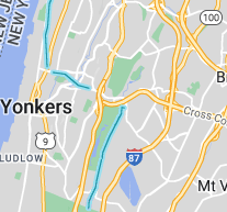
There is a new way to experience the Old Croton Aqueduct State Historic Park…virtually! Trail walker David Windmueller has traversed the 26 miles of the park from the dam to the Bronx border while recording with a GoPro 360 degree camera. Doing it in segments over the last few months, David’s videos were then uploaded using the Google Street View Studio which allows anyone to map out roads and trails for others. These videos are sampled and matched with the uploaded GPS coordinates to allow people to see any part of the trail through Street View.
Having an online version can help in various ways. It allows you to easily make and send links to specific views in the park like of the Lyndhurst grounds. Also walkers can easily see the terrain along the park including some steep hills or other areas that may not be stroller friendly. Another feature is that you can see entry points like from Rockefeller State Park, Tibbets Park or the Lenoir Preserve. Not everything is bucolic. You can also see encroachments on the park like near the Sleepy Hollow High School or Admiral Wordens Lane in Briarcliff Manor and also the occasional unleashed dog on the trail. The online presence also provides a historical snapshot of the trail that can be referenced as things change. Historic Site Park Manager, Steve Oakes said this “... will prove invaluable to me and to prospective and veteran trail walkers for certain.”
To access this view on the web, go to http://google.com/maps and move the screen to the area of interest on the trail. Drag the little yellow pegman on the bottom right and drop on the blue line on the trail. It is also available on Google Maps on your phone by tapping on the layers icon on the top right and selecting the “Street View” button to expose the blue lines. Then tapping on the trail will expose the Street View.
David (pictured at the Croton Dam, below) lives in Cortlandt near the dam and had previously only ventured as far as Dobbs Ferry on the trail and thought it would be a fun project to undertake. Some of the highlights of the trip were the backyard gardens of Sleepy Hollow, noticing a ventilator in Ossining that had previously blended in with its surroundings and finally reaching the Bronx-Yonkers border on the trail. David found that the Friends of the Aqueduct map was invaluable for the walk and he highly recommends getting a copy for your travels. David plans to continue to map out trails in the area in his spare time.

